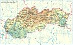
The region Zamagurie is the smallest out of all tourist regions in Slovakia. In the past it belonged together with the mountains of Vysoké Tatry (High Tatras) to the Spiš district (today the region from the town of Levoča to the border with Poland is called Horný Spiš). It is surrounded by the district of Stará Ľubovňa and partially by the district of Kežmarok, from the northern part by the state border with Poland, the rivers Dunajec and Poprad, the Natural Park of Pieniny and Ľubovnianska vrchovina (Ľubovnianska Hills) and in the southwestern part by the mountains of Spišská Magura. With its unusual richness of natural beauties, historical monuments and unique architecture with lively folk traditions of local population of the Gorals it charmed lots of admirers.
Natural beauties together with cordiality of local population make this area a favorite place of peace and relaxation. The administrative center of the region is the town of Stará Ľubovňa with the population of 16 thousand people. It is a typical historical town with a square center from the Middle Ages. In the central square there are many well preserved citizen houses with an early Gothic church from the 13-th century which was later rebuilt in the Baroque style. Above the city there is a castle from the 13-th century with a local gallery and a museum of folk architecture. In the north from the town there is a village Litmanová, nowadays (due to revelation of Holy Mary) the most visited place of the region Zamagurie. The most attractive place for tourists is the village Červený Kláštor (Red Monastery). The origin of its name comes from the monastery (with red rooftops) which was founded by Cartesian monks in the beginning of the 14-th century. In the building of spa there is a seat of the National Park of Pieniny administration. A traditional folk festival is organized here every year in June and an international slalom of Pieniny in September.
From the protected natural areas of the region of Zamagurie we need to mention Haligovské skaly (Haligovské Rocks) - the national natural reservation, Aksamitka - a biggest cave of Pieniny (closed for public), Kamienska tisina - the national natural reservation with the appearance of yew trees, Litmanovský potok - a creek of Litmanová (natural monument with the preserved original ichthyofauna), Jarabinský prielom (natural monument, a canyon valley with 5 cascades and 6 m wide and 3 m deep whirls). The symbol of the region of Zamagurie is the wild and picturesque Natural Park of Pieniny. It is not a big, just 35 km long zone, but it belongs to the most beautiful and the most precious regions of the Central Europe. The majestic rocky formations Tri Koruny (Three Crowns) are the most dominant object in the park of Pieniny. For tourists, the most attractive is a romantic cruise on a typical original rafts used by the local Goral people on the river of Dunajec, through the splendid natural scenery of the National Park of Pieniny (PIENAP). Steep mountains of Pieniny were partially formed by the bordering river of Dunajec, which in the limestone created an 8.5 km long deep and narrow canyon with high slopes. The most beautiful part of the cruise is the Prielom Dunajca (Dunajec Canyon) down to the Prielom Lesnického potoka (Lesnický Creek Canyon). In the summer there is a chance for bathing, swimming and fishing in the clear waters of the rivers Dunajec, Lipnička and Rieka. You also can bike through the area using the marked trails for bicycles. The skiers will enjoy the winter as in the picturesque country there are good facilities for down-hill as well as cross-country skiing (Jezersko).