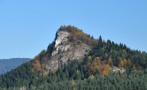
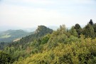
It is a limestone peak situated on the top of the Malé Pieniny (Small Pieniny) mountains with the altitude of 845 m. It is also called Havrania skala (Raven’s Rock). Its silhouette looks like ruins of a castle.
A very steep slope is covered by fir forests and bushes, what makes it even harder to climb up to the top. The easiest way how to get there is to follow the south-eastern path from the Wysokie Wierch up to the steep 50 m high rocky wall sloping to the west. From the top you would have a nice view at the Pieniny National park, High Tatras and Levočské Vrchy (Levoča Mountains).
Vulture White-headed used to nest in this area till 1914 (maybe this is the origin of the name Raven’s Rock).
A story says that in the Zbojnícka jaskyňa (Bush-rangers’ Cave) below Rabštín are still hidden huge treasuries that were gathered by bushrangers who robbed on an important trade route to the Červený Kláštor (Red Monastery) and on open markets.